Recently, there have been news articles about so called “emerging contaminants” in Jordan Lake, such as the below article describing illicit discharges from Burlington. This has caused some concern to a few people who are aware that Jordan Lake is our water source.
Let me start by saying the important part: Our water is perfectly safe, and we have not detected these contaminants at our intake.
We have been testing for these contaminants for years, and have never detected them in any meaningful quantity. The reason is more or less geography: our intake is “up lake” from the Haw (where any contaminants from Burlington would come from). The Haw discharges into Jordan Lake right by the Jordan Lake dam, where it immediately flows south into the Cape Fear River.
Jordan Lake is also massive, which has the effect of diluting any contaminants that do somehow mix “up lake” towards us (this can happen when the dam is intentionally closed to raise the water level, such as ahead to control flooding during extreme weather events)
Our water is safe. If we were to detect PFAS or 1,4 dioxane, I would jump at the chance to join any number of lawsuits to hold the polluters in Burlington accountable. But as it is, I am told Apex has no standing – because we have not detected these chemicals. Pittsboro, which drinks directly from the Haw River, is another story.
None the less, know that Apex and Cary (we have a joint system) have been doing additional testing the past few years as these contaminants have become known. Also, we have an upgraded ozone treatment system at our treatment plant which has been demonstrated to reduce 1,4 Dioxane and related chemicals.
If you are concerned, please review our water quality report below as well as Cary’s emerging contaminants page, which has excellent technical information about what the risks are and what we are doing to combat it.
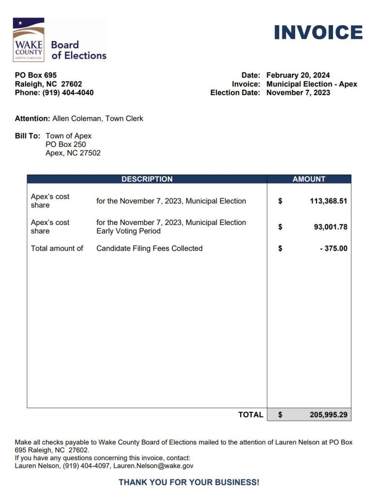
Something to consider: below is the invoice from the Board of Elections for the last municipal election.
We are billed “per precinct” open. We actually got a discount here, because Cary had a runoff. If they did not, our cost in Nov 2023 would have been even higher. Also to note: now that Raleigh has moved to even year elections, our costs have significantly gone up, and as other municipalities move to even, those costs will further shift to the remaining municipalities on odd years.
If we moved to even year elections, the cost in odd years would be $0, and the cost in even years would not increase at all.
This number, around $200k, is roughly equal to our annual sidewalk allocation.
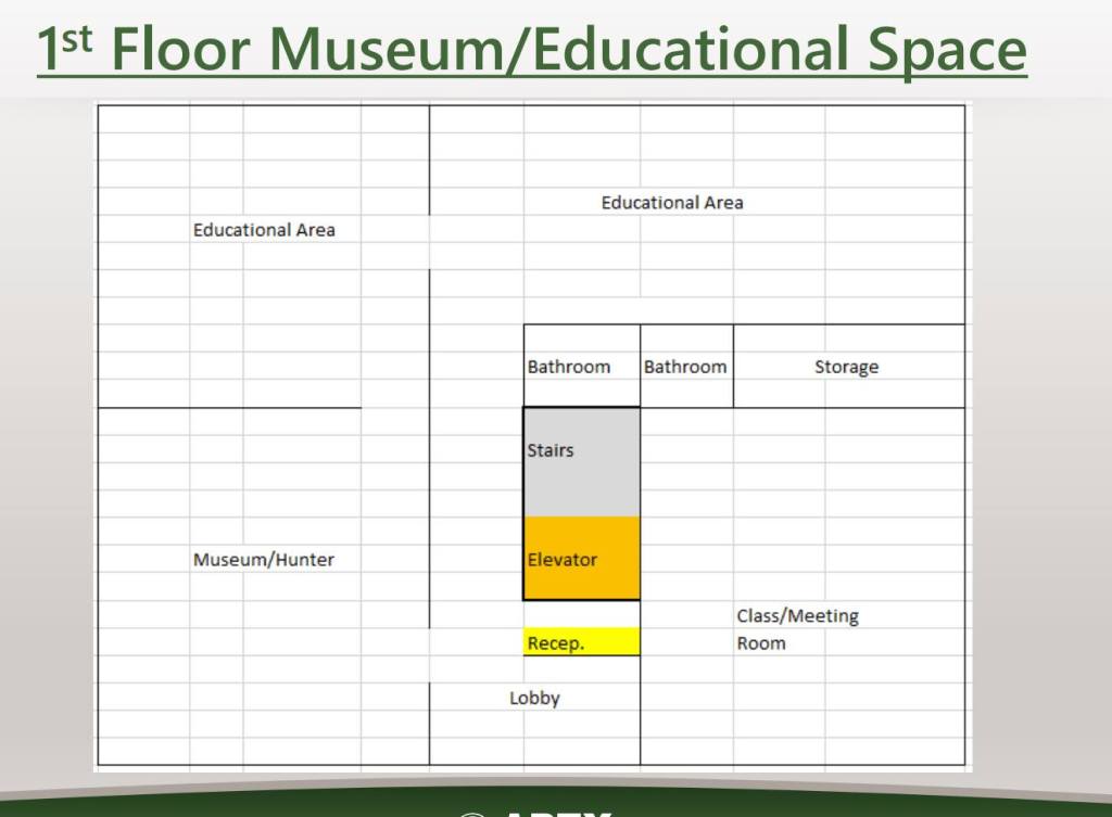
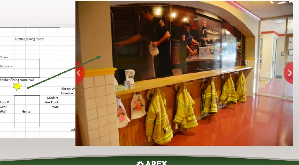
Station 1 is located in the middle of Downtown Apex. It was volunteer built across several years starting in the 50s, and has served as the cornerstone of historic Apex ever since.
Today, we only use one of the seven bays – the rest are too small to hold a modern fire truck. There are also no “plans” for it, exactly… and it’s not up to “code” per se.
So a few years ago (I think this was 2018? early 2019?) the Town Council was faced with a decision. Do we renovate (option 1)? Demolish and build a new fire station in it’s place (option 2)? Or do we demolish, and construct an alternative building there and move the fire station itself to somewhere else (option 3)?
The Fire Chief at the time recommended #3. The Town Council chose Option #2, listening to public feedback desiring a strong AFD presence in the middle of downtown.
That was a few years ago. We now have a new fire chief, and a new town council.
The new Fire Chief, like the previous, again recommended option #3. The primary reason: It turns out a narrow, busy street isn’t the ideal location to station a fire truck. If someone illegal parks across the street, they can’t pull out. If downtown is busy, and there is a call, we have a serious problem (this happened during the Christmas lighting). The recommendation was to put the fire truck itself at Station 3, which is just a few blocks away at Hunter St, and build an administration building where the current fire station is.
We agreed.
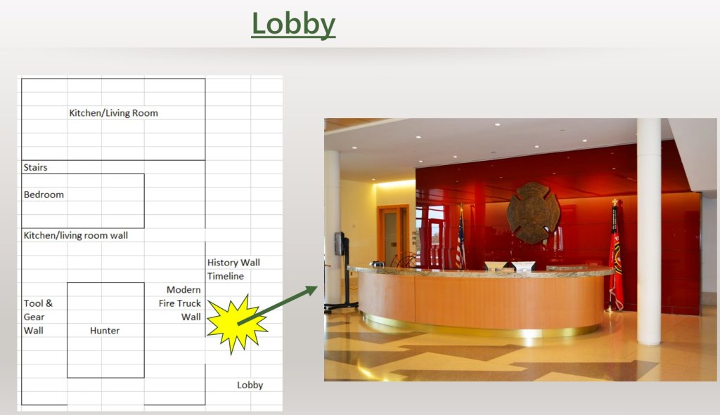
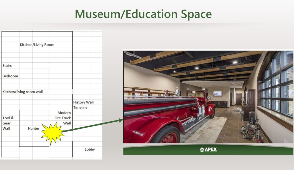
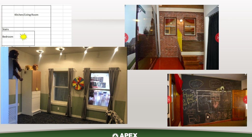
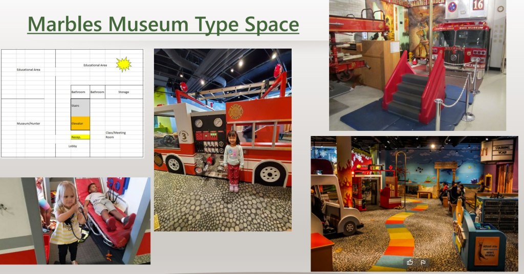
The new fire station, in the chief’s vision, will be a a multipurpose building. It will look like an active fire station with an engine (roll up doors, etc), but the bottom floor will more be a hands on educational experience for the public (and especially the kids). Think Marbles, but for Fire safety specifically. AFD will maintain their strong public presence downtown to interact with the public, but the actual fire engine will be relocated to Station 3, which itself will be renovated and updated.
That’s the big news. I’ll add some pictures from the Chief’s vision presentation, but keep in mind these are concepts: we’d get design firms etc in to actually implement the vision. The station 3 renovations would happen first.
I’m going to make a few different posts, as Day 2 hit on several pretty big topics.
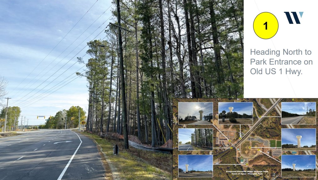
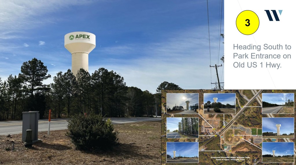
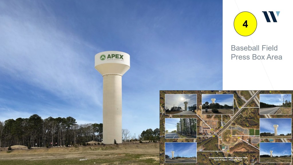
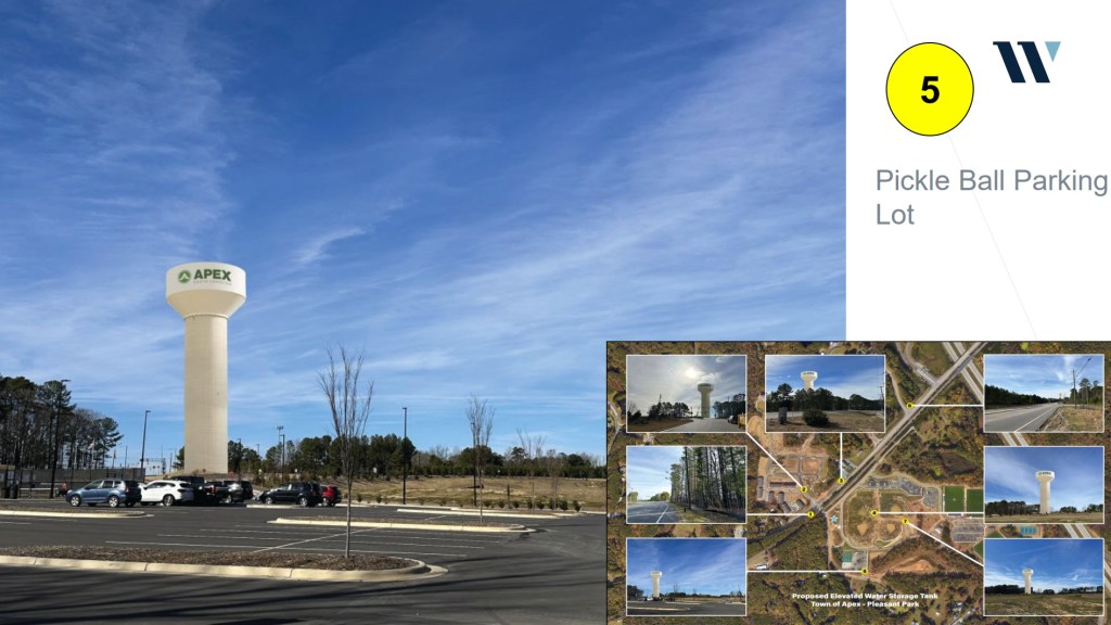
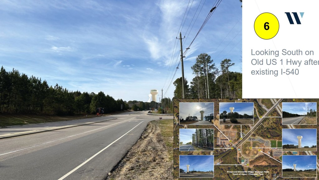
The first is the new Water Tank in the New Hill area.
To recap, part of our infrastructure build out is putting more water “in the air” as they say. Water towers can’t go just anywhere; there are topographical limitations (mostly height) as well as access to the water system (if you build too far away from an existing water main, you have to build out that pipe, which dramatically adds to the cost)
Around two years ago it was decided a new Water Tower would go at Pleasant Park. However, in order to do our due diligence, staff went off and investigated multiple other locations to see if any would be a better fit.
We got a presentation on Friday with the answer – No. There was a nearby site that was considered, but negotiations with the property owner weren’t fruitful, and in any event a pretty significant extension of the water system would have had to be done to the location, disrupting the park.
So we reiterated the decision to move forward with the initial location. It’s shown below; at the North West corner of the park. I’ve also included some renderings from different angles.
We also had a brief discussion about the “style” of the tank. Although it would have been nice to have one which matches the existing tanks, they don’t really build them like that anymore for a variety of reasons (cost, for one, maintenance, etc). The world has kind of moved on to this style tank.
We also had a discussion about the next-next water tank; and possible locations. By Station 3 on Hunter Street is one possibility, but that ties in with the discussions about affordable housing plans and Fire Administration Building discussions, which I’ll post about soon.
The Town Council had a two day retreat this week. Here is what happened on day 1. Both days were recorded and are on town’s YouTube page.
The day opened with a motivational coach; Glenis Redmond – the Poet Laureate of Greenville South Carolina. We started the day with several inspiring poems and stories.
Next we had a couple team building exercises.
Next was a Parks & Rec update, focusing on several greenway projects.
– Beaver Creek Greenway requires several more agreements to be signed (this is the downside of taking so much federal money). Construction should start in March.
– Middle Creek Greenway has started, but the project has encountered more than expected “undercut”. This will require a budget amendment to address.
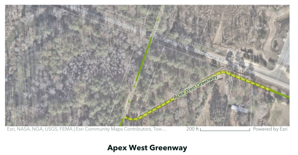
– Apex West Greenway, which eventually will be the last leg of the Beaver Creek connection to the ATT, has also started.
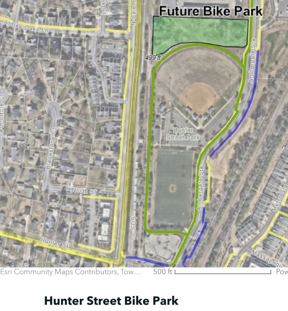
– Upcoming projects: Reedy Branch (just signed the contract last week), this is the connection from Sweetwater, future Bike Park at Hunter Street, and West Street Park.
– Update about Pleasant Park: we estimate two million visitors since opening; which is almost double what was estimated (!!).
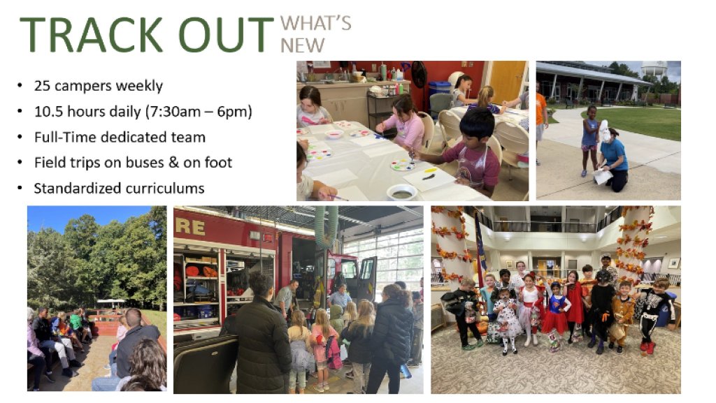
– We got an update of the new Track Out camps funded last year. We now have full time track out camps with 25 spots per week; more than 4 times the capacity of prior years. The programming has also expanded with multiple field trips per week.
After Parks and Rec finished, we got an update from UNC School of Government about a workplace conditions survey. More data to come.
We then had a DEI training session.
We got an update about our language access plan.
Finally, we got an our annual Affordable Housing Report, which is an annual report called for as part of our Affordable Housing Plan. Lots of progress last year, but a long way to go.
So, what can you do and what do you need to know if you think your property valuation is incorrect? A few things.
First, know that your property valuation going up doesn’t mean your tax bill will go up by the same amount. What matters is your property valuation change relative to everyone else.
Second, I want to be clear: if you appeal your valuation, there is a chance the property value on appeal will actually go up. So, I only recommend appealing for people who have some reason to believe (comparable sales, etc.) the valuation is wrong, or can show that something is factually wrong with the data on the home (ie wrong square footage)
Next: if you believe an error has been made, go to this website to file an informal appeal (deadline 3/1). If that doesn’t work out, you can then file a formal appeal (deadline 3/15). There is a video here you should watch.
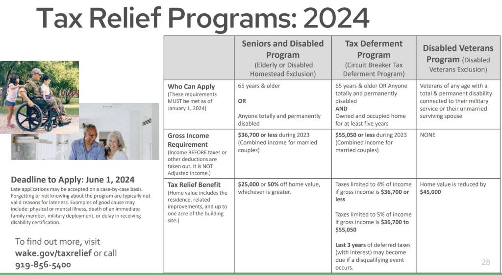
Finally, I want everyone to be aware of the tax relief programs available. Unfortunately we don’t have any control over this (they have to be uniform state wide, and are controlled by the state). But if you are 65 or older, have a disability, are a disabled veteran, and meet certain income requirements, you may be eligible for some tax relief or tax deferral. I included below the summary chart from the county of the programs available.
Next we considered an annexation petition for a property on Holt Road. This property had a rezoning turned down, but the property owner applied for a variance to allow them to develop, and was approved by the Board of Adjustment. I voted against the annexation, but it was approved 4-1 (Mahaffey)
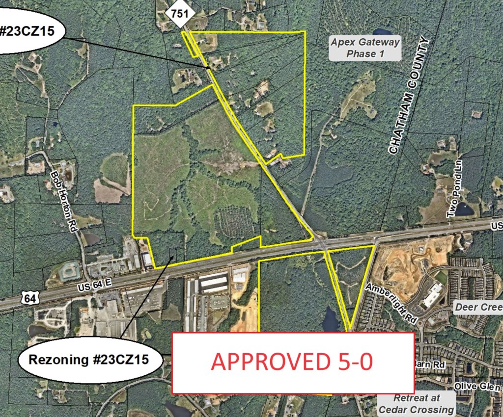
Apex Gateway Phase II came back with an amendment to their rezoning petition. This is the project located near 751 and 64. This amendment added more commercial services to the project, which was something I had initially pushed for (and gotten) in the initial application, to meet the needs of neighbors. This amendment, driven more by market demand than anything, pushes that further. I believe this is a benefit to the community. It passed 5-0.
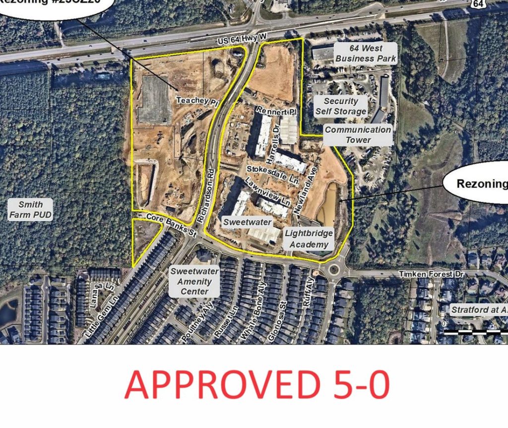
Next up: A Sweetwater PUD amendment. This amendment asked for permission for an additional story on a commercial building, as well as removing some amount of required office space. The office space request made sense, as the market for office space as changed significantly since Sweetwater was originally approved a decade ago. I am not pleased with the height amendment, and Sweetwater has come back to us many many times: including a request to remove a reservation for NCDOT, allegedly for a hotel, which I have since learned will not end up being used for the hotel. Regardless, it wasn’t entirely germane to this request, so I voted to approve it to be consistent with previous town actions in trying to bring a hotel with event space to Apex. I look forward to hearing about the next Sweetwater PUD amendment in a few months I’m assuming. Passed 5-0.
Next up, “Salem Street Townhomes” PUD, a small project which did a great job working with the community to address parking concerns. Enthusiastically approved 5-0 with the support of neighbors.
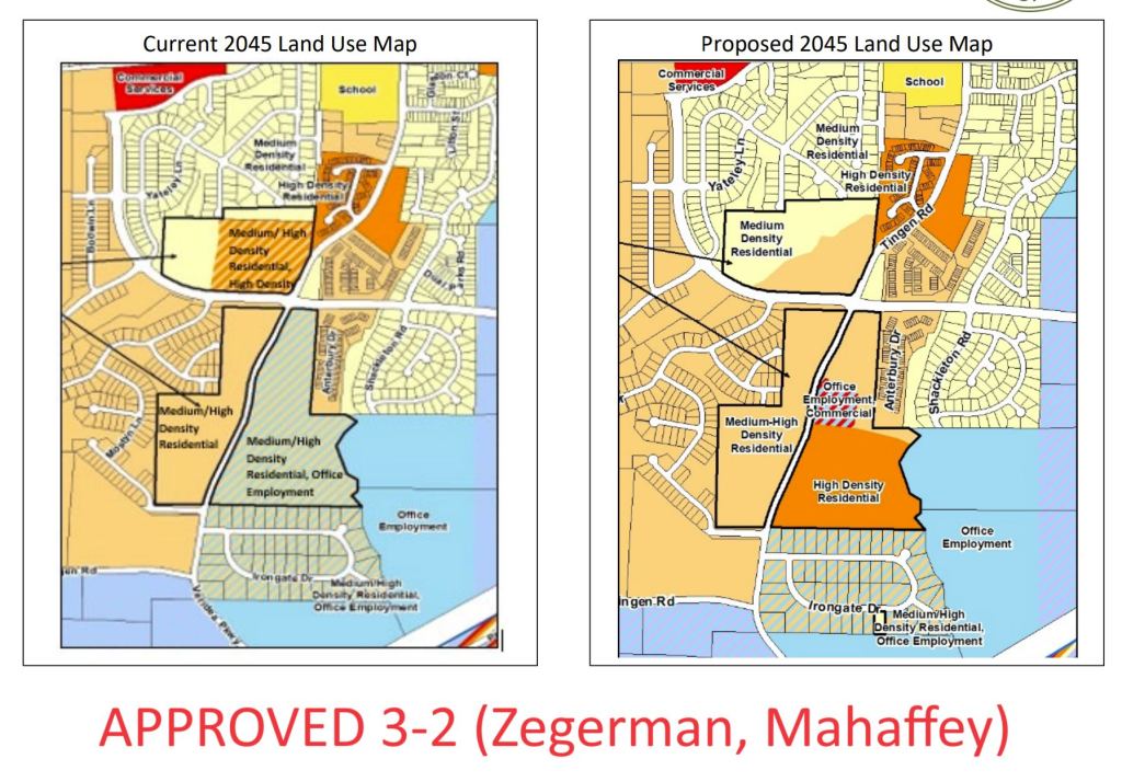
Finally, the big one of the night: Seymour PUD. This was a project centered around the corner of Tingen and the Peakway, near Salem Village. There is a lot that went on here, as it was a complicated proposal, mostly because this a very complicated section of the land use map: they had assembled a project which contained pieces of at least 4 different land use designations, and to their credit they attempted to put together a project which met the spirit of map (even though their districts didn’t line up exactly with the land use map, which resulted in at least one no vote at the planning board)
I think it’s important to point out that the overall density of the project was 20% lower than the density allowed by the map, with the lower density clustered by Salem Village.
Another contentious issue was stub street connections. I hope I can say this more eloquently than some of my colleagues did, but I do want to be blunt and straight to the point: We connect all stub streets. Always. It’s required by law. Although in theory we could change the law, we never have before, even though it is requested for us to not make the connection on every stub street. I just want to be clear, if you currently live on a stub street, and a development adjacent to you is approved, the stub street absolutely will be connected to that development and there is no chance you could prevent it short of buying the connecting property yourself and choosing not to develop it.
I ultimately voted against this project, which passed, 3-2 (Zegerman, Mahaffey)
Since our first Town Council Meeting in January was canceled, our agenda tonight was lengthy. The meeting lasted past midnight, addressing multiple controversial topics.
We received a report on our annual audit. I often hear calls for an audit of the town’s finances; it’s actually a state law requirement for every government body to receive such an external audit annually. Our report was clean. We also discussed appropriate debt servicing levels. See the report here
Public Comment had numerous speakers, many voicing their support for an Oak tree on Hunter Street. There are currently no plans to remove the Oak tree. That sidewalk section is still in design. It was deprioritized and removed from our 23-24 project list nearly a year ago when the design constraints became apparent to staff so it didn’t slow down other segments.
Many argued that this sidewalk segment is unnecessary, claiming that sidewalks on one side of the street are sufficient and thus the project should be abandoned. I respectfully disagree, especially in a downtown area, and particularly within two blocks of a school. Just yesterday in Cary, there was a pedestrian fatality in a crosswalk, and two years ago, a child on their way to Friendship Middle was seriously injured in a crosswalk. Requiring pedestrians to cross the street multiple times to avoid gaps is not a solution, especially in high pedestrian and high traffic areas like the downtown core and near schools. We can do better. We will do better. We can move the street if necessary.
Moving on.
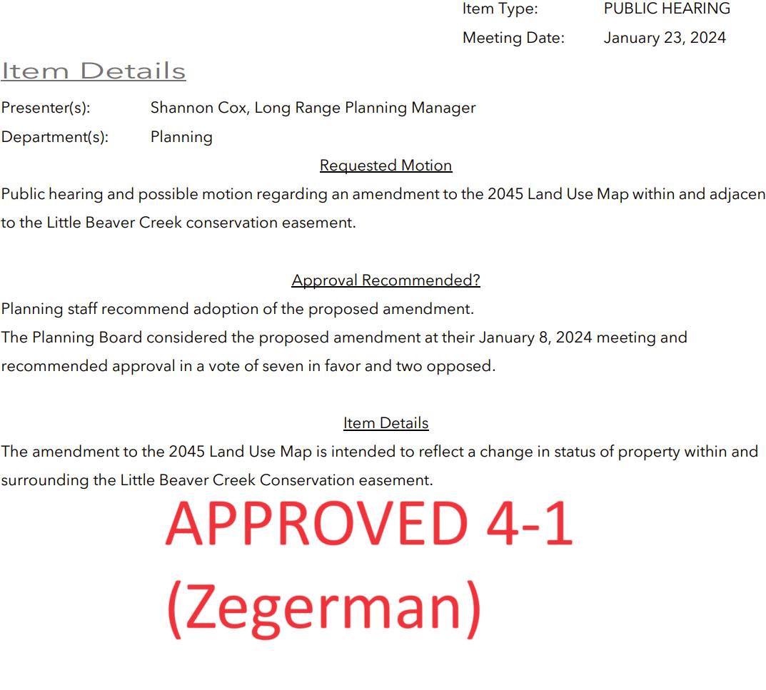
The next item was an administrative change to update our land use map, reflecting a conservation easement swap that occurred in the Friendship area. Here’s what I’ve learned: about 25 years ago, Richardson Road was added to an early version of our Long Range Transportation Plan (outlining a future road network across our entire planning area). Some property owners objected and advocated for an alternative route that didn’t intersect their property. Soon after a conservation easement was recorded over the proposed path of Richardson (DEQ has since revised their policies, preventing conservation easements that conflict with published municipal plans, but at the time, it was permitted). Over the next decade, negotiations with both the state and the property owner who recorded the easement took place. In 2016, both parties agreed in principle to allow the stream crossing and release that portion of the easement, after multiple studies concluded that the proposed path was the least environmentally impactful. The deal was finalized in 2021.
Our action this past Tuesday was not an approval of that deal—it had already been approved. We were simply updating a map to reflect the transaction. Not updating the map would not have nullified the transaction; we would have just been left an inaccurate map. A meeting and formal vote is required by state law for even minor changes to this map.
A few key points:
Our Long Range Transportation Plan includes a complete network of roads for the entire expanded area under our planning jurisdiction. The mere existence of a future road on this map does not indicate the town has any plans to acquire property for road construction. I do think there is significant misunderstanding on this point. This map serves as a guide for future development, allowing us to require developers to build parts of this plan, ensuring a cohesive and logical road network. Richardson Road is not unique in this regard; there are many future roads on this map. If you’re opposed to a road depicted in this plan, my advice is to refrain from selling your property to developers.
Our Transportation CIP documents the Town’s plans for future construction. Richardson Road is not there, neither as a plan within the 5-year horizon nor as a “future” project for the 5-10 year range. It will be built as development occurs. Or not.
The conservation swap agreed upon several years ago was a massive win for conservation efforts. There is a process for exchanging these easements, and it was meticulously followed over the course of a decade. It was agreed to by the property owner, and the state. The area newly designated for conservation is four times larger than the original conservation area. The Town of Apex contributed substantially towards additional conservation efforts. The final path for Richardson Road over this creek, determined a decade ago to be the least environmentally impactful, will be constructed to minimize impacts. This deal was endorsed by multiple agencies after a comprehensive review spanning years.
I’ll stress again we weren’t actually considering the swap itself, or voting on it.
The Land Use Map change was approved by a 4-1 vote, with CM Zegerman dissenting.
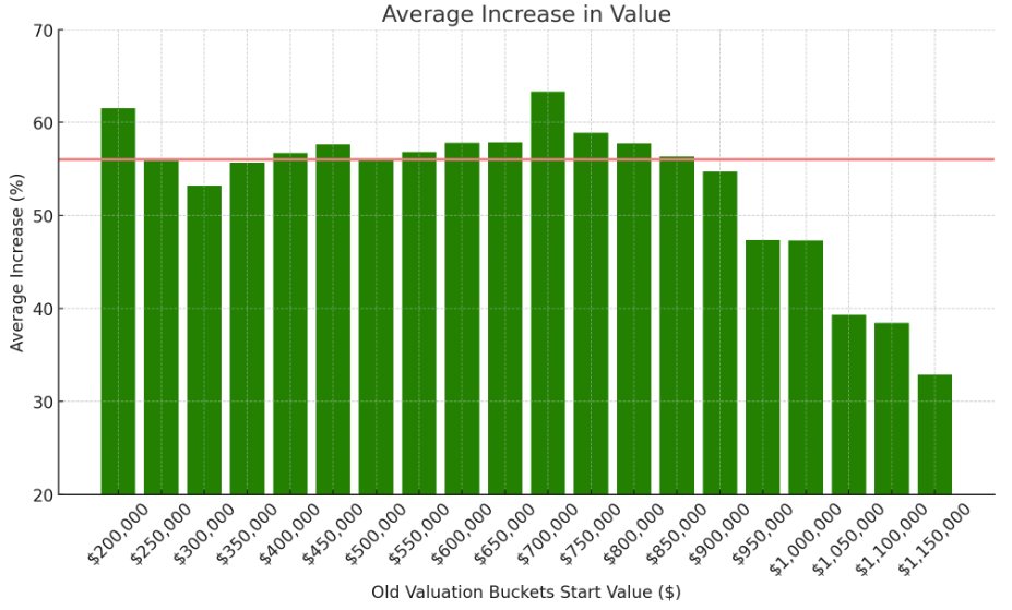
I promised some data about what exactly happened to property valuations in Apex. All the below data only deals with residential properties which existed in 2020.
First, I wanted to see how the “curve” of property values have shifted in 4 years. The median home value in Apex has increased from $365k to around $570k, which is massive, but it’s interesting to see that the “curve” has flatted some.
Additionally, a major concern I had was that the increase in valuation would be heavier on the lower end of the property valuation range. The net result here is this would shift the tax burden to those with lower value homes, and give a tax cut to those with really expensive homes. Indeed, that is what happened, but it’s not as dramatic as I had feared. People whose homes were valued close to $1,000,000 or more in 2020 indeed got a tax cut, but that additional tax burden is shifted pretty evenly across the homes below that value. I added a line at 56% to give a rough idea as to where the tax neutral value increase would be.
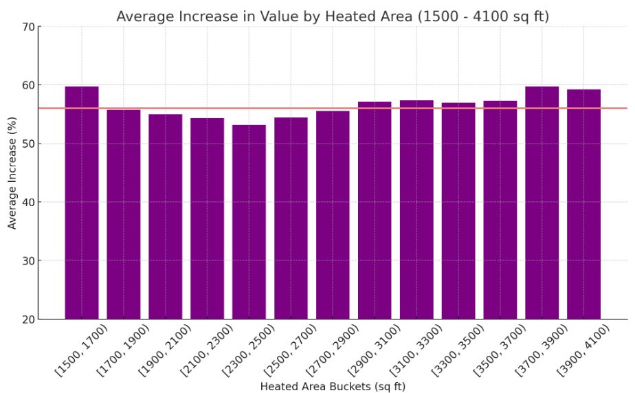
I also charted the same data based on heated area (square ft), but this was relatively uniform.
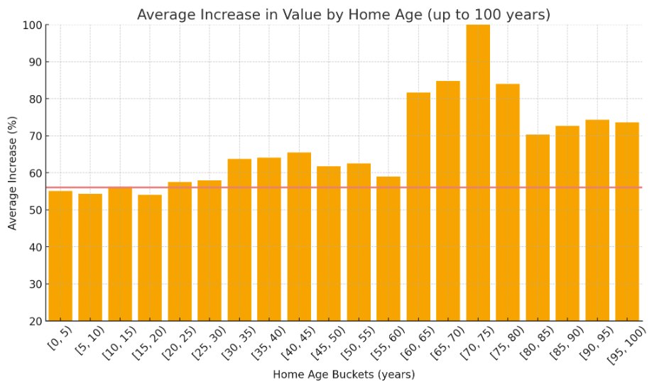
More interesting was charting based on home age. Older homes increased in value noticeably more than younger homes!
What about where the increases are? Here is a list of the Top 10 Streets with the largest average increase in value:
OLD US 1: 232.99%
CULVERT: 105.36%
CASTLEBERRY: 99.93%
GROVE: 99.45%
WHITE OAK BRANCH: 96.82%
WRENN: 96.42%
SALIENT: 94.88%
KEITH: 94.76%
IRONGATE: 92.60%
WHITE OAK CREEK: 91.31%
And here are the streets with the Lowest 10 Average Increases, and are in line for significant tax reductions:
GOLIATH: 27.61%
EDWARDS POND: 28.82%
SATTERFIELD: 30.70%
MASONBORO FERRY: 31.61%
DALLAS VALLEY: 32.94%
LAUDER: 35.73%
GLASTON: 36.08%
DILLY DALLY: 36.74%
ELBURY: 37.08%
DALTON RIDGE: 37.20%
If you read this far, I hope you found this data insightful. Let me know if you have any thoughts or questions.
Hopefully by now you’ve heard that a property revaluation of X% isn’t going to translate into a tax increase of X%. They are two different things, and the tax rate is going to drop such that the change is revenue neutral.
I have written a lot about that – so today instead I want to talk about a few other consequences of the property reval that aren’t as obvious.
Costs for Car Registration Renewal Will Go Down
So, it turns out that the high cost of car registration renewal is actually because property tax get assessed on vehicles as well. With home valuations going up, and tax rates going down, and car vehicle values staying the same or going down, we’re going to see a large decrease in car registration costs starting next year.
This Revaluation Favors Residential
Residential properties have gone up in value more than commercial values have. This is the opposite of what we saw in 2020. This means that the overall tax burden has shifted slightly away from commercial and towards residential (which is generally considered bad). This, again, is the opposite of what happened in 2020 when the tax burden shifted more commercial.
There isn’t much we can do about this; the property values are the property values and are determined by the market. But towns like Apex can be more intentional about shifting to more commercial zoning where it makes sense.
Policies Which Shift Costs Out of General Fund Are Good, Actually
I hope this revaluation process highlights the fact that things funded by property taxes (most anything in the general fund) are regressive by nature. That’s not great.
The alternative is to pull things out of the general funded and utilize other funding sources, where possible. Those sources of funding may have more flexibility in how they are structured, so they are not necessarily as regressive as property taxes. The best example of this I can think of is when we created the Stormwater utility a few years ago.